 打印
打印
基于载人航天平台的林业遥感应用
编号
lyqk004238


中文标题
基于载人航天平台的林业遥感应用
作者单位
中国林业科学研究院资源信息研究所,北京 100091;中国林业科学研究院资源信息研究所,北京 100091;马里兰大学地理系,美国马里兰 20742;中国林业科学研究院资源信息研究所,北京 100091;中国林业科学研究院资源信息研究所,北京 100091;中国林业科学研究院资源信息研究所,北京 100091;中国林业科学研究院资源信息研究所,北京 100091
期刊名称
世界林业研究
年份
2013
卷号
26
期号
4
栏目编号
1
栏目名称
专题论述
中文摘要
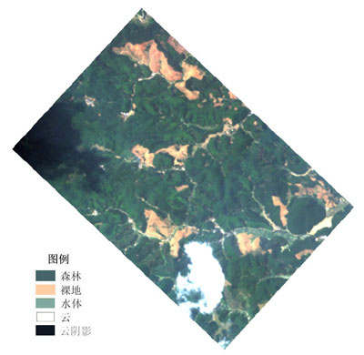
介绍了载人航天工程的概况,阐述了以载人航天器为平台的对地观测遥感技术的发展,重点分析了载人航天平台遥感的技术优势,从高分辨率、高光谱和热红外、合成孔径雷达和激光雷达等5个方面简介林业应用情况;以高光谱数据为例,介绍了基于我国天宫一号载人航天平台遥感数据的林业应用情况;并对国内外空间站计划的林业应用潜力进行了展望。
关键词
载人航天平台
林业遥感
国际空间站
天宫一号
神舟飞船
基金项目
国家科技部“863”全球森林生物量和碳储量遥感估测关键技术(2012AA12A306);国家载人航天工程天宫一号林业应用;国家留学回国人员科技活动择优资助项目森林参数与碳储量精确测量激光雷达卫星参数选择研究
英文标题
Forest Remote Sensing Applications Using Manned Spacecrafts Data
作者英文名
Pang Yong,Li Zengyuan,Sun Guoqing,Gao Zhihai,Qin Xianlin,Tan Bingxiang and Chen Erxue
单位英文名
Institute of Forest Resource Information Techniques,Chinese Academy of Forestry,Beijing 100091,China;Institute of Forest Resource Information Techniques,Chinese Academy of Forestry,Beijing 100091,China;Department of Geography,University of Maryland,College Park,MD 20742,USA;Institute of Forest Resource Information Techniques,Chinese Academy of Forestry,Beijing 100091,China;Institute of Forest Resource Information Techniques,Chinese Academy of Forestry,Beijing 100091,China;Institute of Forest Resource Information Techniques,Chinese Academy of Forestry,Beijing 100091,China;Institute of Forest Resource Information Techniques,Chinese Academy of Forestry,Beijing 100091,China
英文摘要
The paper overviewed the manned space flight missions, and described the development of remote sensing in manned spacecrafts, with the focus on its technology advantages. Its application to forestry sector was introduced in terms of high spatial resolution, hyperspectral, thermal, SAR and lidar. With hyperspectral data as an example, the paper introduced the application of hyperspectral data from China TG-1 to forestry. The potential to take advantage of space station program in forestry development were prospected.
英文关键词
manned spacecraft;forest remote sensing;ISS;TG-1;SZ Spacecraft
起始页码
43
截止页码
49
投稿时间
2013/3/6
分类号
S771.8;TP79
参考文献
[1] 韦娟,宁方立,黄永宣.地球观测科学的发展以及空间站对地观测[J].飞行力学,2003(2):8-12.
[2] 王峰,周峰,郑国宪,等.中国空间站光学遥感载荷的发展研究[J].航天返回与遥感,2010(5):27-31.
[3] 中国载人航天工程网.中国载人空间站简介[EB/OL].(2011-04).[2012-03-02]. http://www.cmse.gov.cn/project/show.php?itemid=480.
[4] NASA. Overview of window observational research facility (WORF)[EB/OL].[2012-03-02].http://worf.msfc.nasa.gov/index.html.
[5] Olsen D R,Kim H J,Ranganathan J,et al.Development of a low-cost student-built multi-spectral sensor for the International Space Station[C].SPIE Optics + Photonics 2011,San Diego,CA,USA,August 12-16,2011.
[6] Shine S,Sever T,Componation P,et al.Utilizing the International Space Station as an alternative to support the regional visualization and monitoring system[C]//Proceedings of the 63rd IAC (International Astronautical Congress), Naples, Italy, Oct. 1-5, 2012.
[7] 胡秀清,刘京晶,邱康睦,等.神舟3号飞船中分辨率成像光谱仪场地替代定标新方法研究[J].光谱学与光谱分析,2009,29(5): 1153-1159.
[8] 刘兆军,高军,忻刚,等.应用于小卫星平台的中分辨率成像光谱仪[J].航天返回与遥感,2002,23(2):21-27.
[9] 中国科学院.神舟飞船陆地遥感应用系统研究通过鉴定[EB/OL]. (2004).[2013-02-11].http://www.cas.cn/ky/kyjz/200404/t20040415_1031719.shtml.
[10] Lucke R L,Corson M, McGlothlin N R,et al. Hyperspectral imager for the coastal ocean: instrument description and first images[J]. Applied Optics,2011,50(11):1501-1516.
[11] Wu S T.Analysis of data acquired by shuttle imaging radar SIR-A and LANDSAT thematic mapper over Baldwin county, Alabama[C]. International Symposium-Machine Processing of Remotely Sensed Data, 1985.
[12] Werle D.Shuttle imaging radar (SIR-A) observations of large-scale afforestation efforts in the People's Republic of China[C]. International Geoscience and Remote Sensing Symposium (IGARSS), v 3, 1989 :1410-1413.
[13] Sun G, Simonett D. A composite L-band radar backscattering model for coniferous forest stands[J]. Photogrammetric Engineering and Remote Sensing, 1988,54(8):1195-1201.
[14] Evans D L, Plaut J J, Stofen E R. Overview of the spaceborne imaging radar-C/X-band synthetic aperture radar (SIR-C/X-SAR) missions[J]. Remote Sensing of Environment, 1997, 59(2):135-140.
[15] Dobson M C,Ulaby F T,Pierce L E,et al. Estimation of forest biophysical characteristics in northern Michigan with SIR-C/X-SAR[J]. IEEE Transactions On Geoscience And Remote Sensing, 1995,33(4):877-895.
[16] Ranson K J,Sun G Q.An evaluation of AIRSAR and SIR-C/X-SAR images for mapping northern forest attributes in Maine,USA[J]. Remote Sensing of Environment,1997, 59(2):203-222.
[17] Ranson K J,Saatchi S,Sun G Q.Boreal forest ecosystem characterization with SIR-C/X-SAR[J]. IEEE Transactions on Geoscience and Remote Sensing,1995,33(4):867-876.
[18] 庞勇,李增元,陈尔学,等.雷达干涉测量与林分高估测[J].遥感学报,2003,7(1):8-13.
[19] 陈尔学,李增元,庞勇,等.基于极化合成孔径雷达干涉测量的平均树高提取技术[J].林业科学,2007,43(4):66-70.
[20] Pierce L E, Bergen K M, Dobson M C,et al.Multitemporal land-cover classification using SIR-C/X-SAR imagery[J]. Remote Sensing of Environment,1998,64(1):20-33.
[21] Saatchi S S, Soares J V, Alves D S.Mapping deforestation and land use in amazon rainforest by using SIR-C imagery[J]. Remote Sensing of Environment,1997,59(2):191-202.
[22] Yanasse C C F,Sant'Anna S J S,Frery A C,et al.Exploratory study of the relationship between tropical forest regeneration stages and SIR-C L and C data[J].Remote Sensing of Environment,1997,59(2):180-190.
[23] Bergen K M,Dobson M C,Pierce L E,et al.Characterizing carbon in a northern forest by using SIR-C/X-SAR imagery[J]. Remote Sensing of Environment,1998,63(1):24-39.
[24] Farr T G,Rosen P,Caro E,et al.The shuttle radar topography mission[J].Reviews of Geophysics,2007,45(2):doi:10.1029/2005RG000183.
[25] Kellndorfer J M,Walker W S,Pierce L E,et al.Vegetation height estimation from shuttle radar topography mission and national elevation datasets[J].Remote Sensing of Environment,2004,93(3):339-358.
[26] Sun G K,Ranson J,Bufton J,et al.Use of Shuttle Laser Altimeter (SLA) data as tie points for reducing the error of INSAR generated digital elevation model[J].Photogrammetric Engineering and Remote Sensing,2000,66(1):81-85.
[27] Sun G,Ranson K J,Kharuk V I,et al.Validation of surface height from shuttle radar topography mission using shuttle laser altimeter[J].Remote Sensing of Environment,2003,88(4):401-411.
[28] Asai K,Sawada H,Sugimoto N,et al.iLOVE:iss-jem lidar for observation of vegetation environment[C]//Proceedings SPIE 8526,Lidar Remote Sensing for Environmental Monitoring XIII, Kyoto, Japan, November 19, 2012:doi:10.1117/12.981326.
[29] 中国载人航天工程网.天宫一号空间应用成果展示[EB/OL].[2013-03-01].http://www.cmse.gov.cn/news/list.php?catid=459.
PDF全文
浏览全文
-
相关记录
更多
- 线性混合像元分解及其在林业中的应用 2017
- 林业遥感云平台的系统结构与功能设计 2013
- 世界林业航天遥感进展 1993
相关图谱
相关动态
相关信息